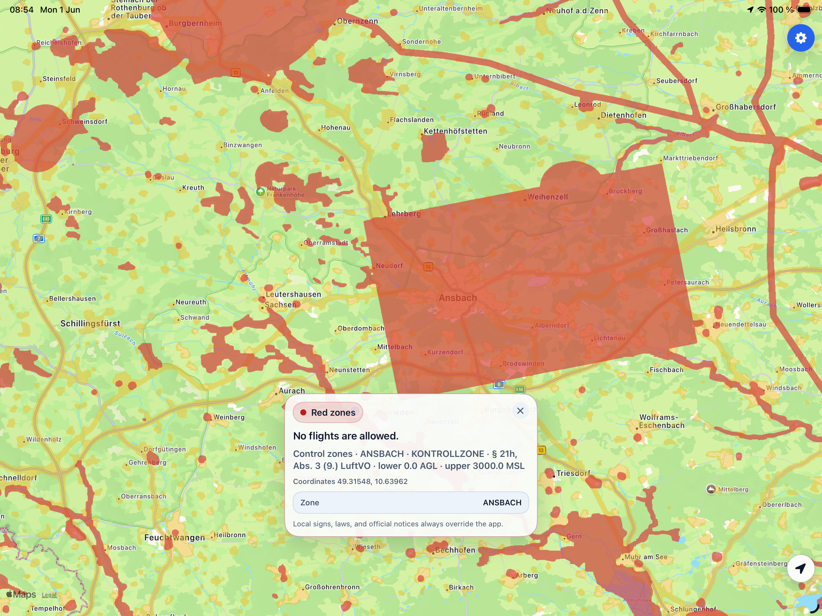
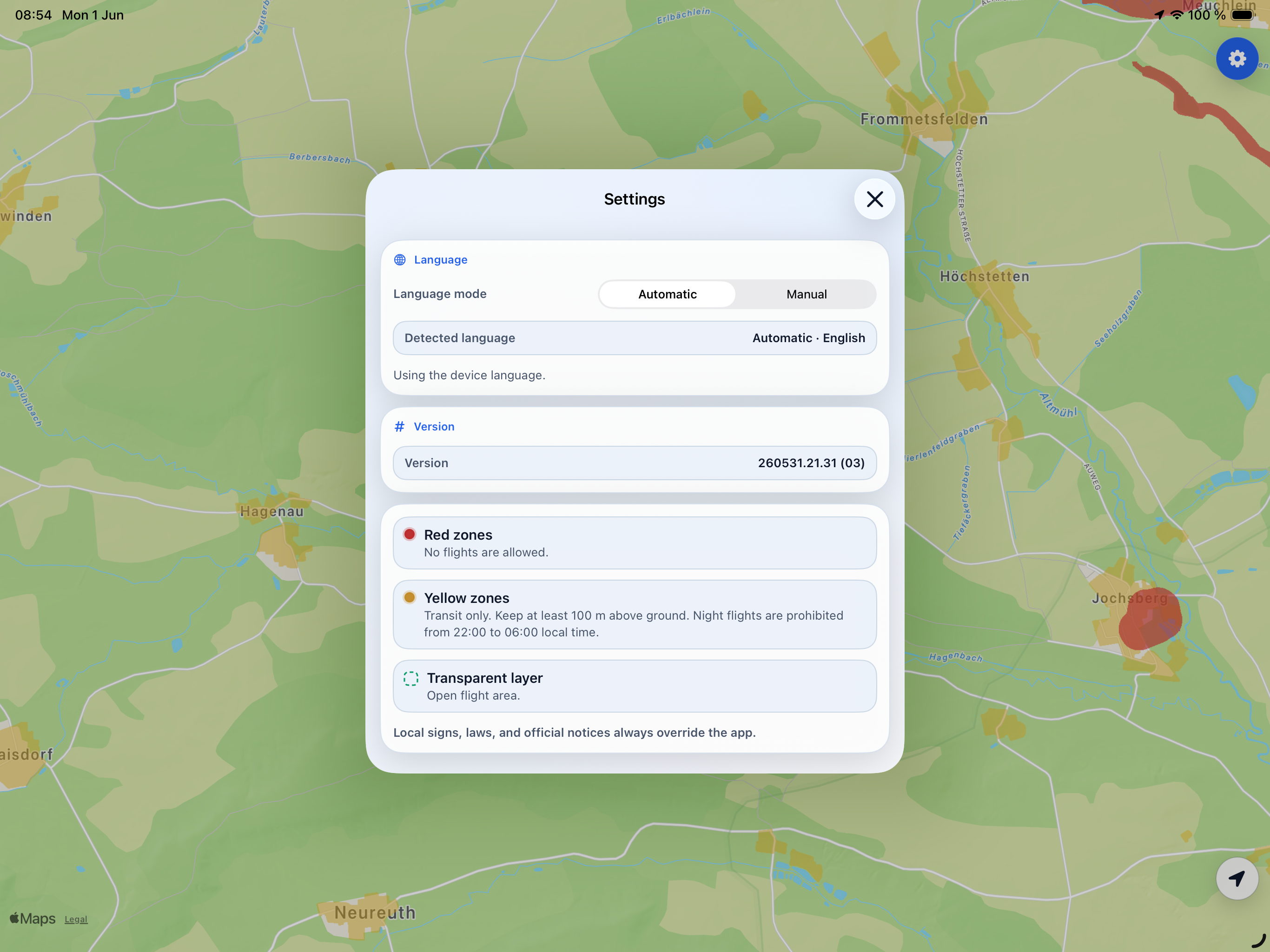
Airspace restriction maps
DroneMeld
Simple airspace checking for drones.
No overloaded aviation maps, unnecessary layers, or technical clutter.
DroneMeld is built for everyday drone pilots who need one simple answer:
- Flight prohibited
- Flight possible with restrictions
- Airspace open
Main Idea
Most drone applications are overloaded with:
- dozens of aviation layers,
- complex markings,
- professional terminology,
- weather data,
- wind information,
- NOTAM codes,
- aviation details that are confusing for regular users.
DroneMeld solves only one problem:
Airspace checking.
Without the overload.
What DroneMeld Does
Checks:
- no-fly zones,
- CTR areas,
- military zones,
- restricted areas,
- temporary restrictions,
- coordinate-based airspace limitations.
What DroneMeld Does NOT Do
DroneMeld is NOT:
- a flight planner,
- a weather application,
- a navigation system,
- a drone control system,
- a professional aviation GIS platform.
Why DroneMeld Is Different
Minimalism
Instead of dozens of layers, users only see:
Red zones
Complete flight prohibition.
Yellow zones
Flight allowed with restrictions.
Everything else
Airspace is open.
No “Card Clutter”
DroneMeld does NOT display:
- complicated aviation codes,
- overloaded legends,
- professional GIS layers,
- unnecessary data.
Only what matters to the pilot.
How It Works
- The user opens the map.
- Selects a location.
- DroneMeld checks the airspace.
- The user receives a clear status.
Official Data Sources
DroneMeld uses:
- official aviation data,
- government sources,
- up-to-date airspace restrictions,
- NOTAMs and published zones.
Important
DroneMeld displays airspace status information.
The application does NOT verify:
- takeoff permission,
- landing permission,
- private property access,
- local on-site restrictions.
Responsibility for complying with local regulations remains with the drone operator.
Who DroneMeld Is For
- DJI / Autel / FPV drone owners,
- A1/A3 pilots,
- beginner pilots,
- travelers,
- photo and video creators,
- users who need a fast and understandable answer.
Key Advantages
Simplicity
No aviation overload.
Speed
Checks completed in seconds.
Clarity
Only important restrictions.
Clean Interface
No dozens of unnecessary layers.
Focused on the Real Task
Understanding one thing:
Can you fly or not?
DroneMeld Philosophy
DroneMeld does not try to replace professional aviation systems.
DroneMeld is designed as:
a simple and clear airspace checking tool for everyday drone pilots.
But the core of DroneMeld will always remain simple:
minimum noise — maximum clarity.
Chrome-Stats does not own this Apple app. Please use these information below to contact the Apple app developer.