Smart sea maps for boating
Sea Maps helps boaters and fisherman stay safe, plan better, and make the most of every trip with live ocean data and interactive overlays—right on your Phone.
Sea Maps is a marine navigation and weather app designed for boaters, anglers, and ocean explorers.
Enjoy a free trial, then continue with a paid subscription to access all core features, including weather overlays, AIS vessel tracking, and advanced marine charts.
Sea Maps Features
-Core Navigation & Mapping
Interactive map with multiple map types (Water World, Satellite, Streets, Hybrid, Moonlight, Ocean Contours)
GPS location services with real-time user position tracking
Automatic region management and centering.
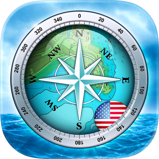
-Navigation & Compass
Full-screen compass display with magnetic heading indicator
Speed Over Ground (SOG) in real-time (knots)
Bearing to pin: Green arrow showing direction to dropped pin
Minimized heading view at top of screen
Track recording: Start/stop with map snapshots
Background location tracking
-Marker & Pin System
Dropped pin information popup with precise coordinates
Latitude/Longitude display in DMS format (Degrees, Minutes, Seconds)
Distance calculation from current location to pin
Ocean current data at pin location (speed & direction)
Sea surface temperature at pin location
Pin management & removal
Save custom markers with names and descriptions
-Marine Weather & Ocean Data
Sea Surface Temperature (SST) - Heat map with customizable temperature range (15-28°C)
Ocean Winds - Wind speed heat map with animated wind particles and direction indicators
Ocean Currents - Current flow visualization with particle animation
Visible Satellite Imagery - Real-time satellite overlay
Wind Animation Timeline - Play/pause/scrub controls for wind data
Marine Forecast System - 7-day weather forecast with tide, swell, wind, and ocean current charts
Weather Icons - Colour-coded weather conditions with moon phases
-AIS (Automatic Identification System)
Real-time AIS vessel tracking and information
Detailed ship information popup with position, speed, heading
Ship type classification and categorisation
-Bathymetry & Charts
Bathymetry Overlay - Ocean depth contours with configurable visualisation
Navigation Aid Markers - Buoys, lights, and other maritime markers
Chart Data Caching - Local storage for offline access
-Safety & Monitoring
Anchor Alarm System - Geofencing with configurable radius (50m default)
Real-time Distance Monitoring - Continuous tracking from anchor point
Background Location Tracking - Continuous monitoring even when app is closed
Customizable Alarm Radius - Adjustable geofence size
Track Management - GPS route recording with timestamps and custom naming
Track Visualization - Display recorded routes on map
Map Snapshots - Capture track data with map images
-Settings & Customization
Map Type Selection - Grid-based interface for choosing map styles
Unit Conversions - Temperature (Celsius/Fahrenheit) and speed (Metric/Imperial)
Accessibility Support - Dynamic text sizing
-Subscription Details
Sea Maps requires an active subscription to access app features.
Pricing and duration are displayed in the app before purchase.
A free trial is available for new users.
Manage or cancel anytime through your App Store account settings.
-Terms and Policies
Privacy Policy
https://www.appaspires.com/privacy/privacy.pdf
Terms of Use
https://www.appaspires.com/terms/termsofuse.pdf
Chrome-Stats does not own this Apple app. Please use these information below to contact the Apple app developer.

 (100)
(100)