


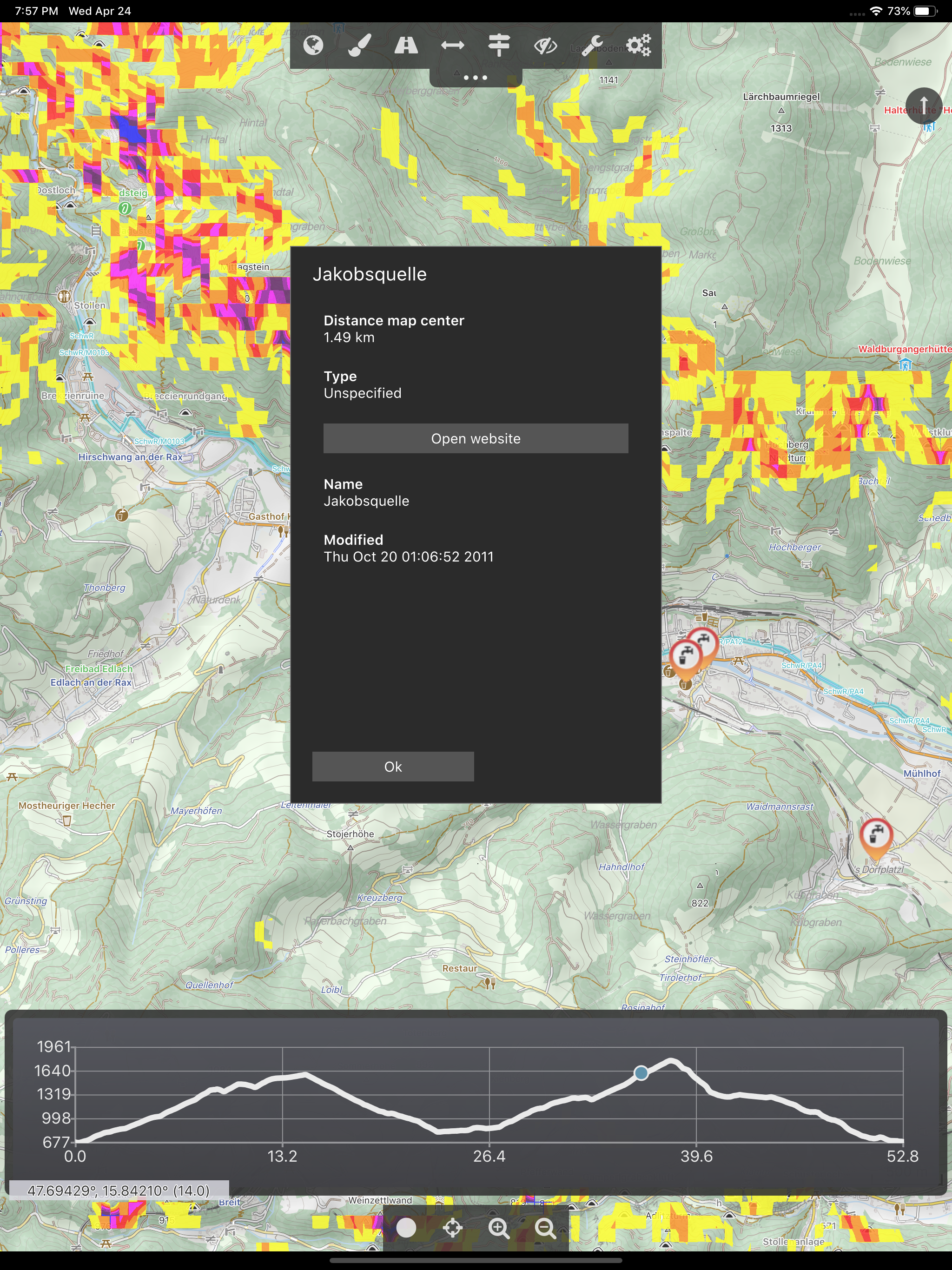
Features & Capabilities
User Growth & Download Statistics
App
- By:
- Harald Meyer
- Version:
- 2.8.1 Last updated: 2022-05-11
- Version code:
- 848985323
- Creation date:
- 2016-02-29

- Compatible devices:
- Size:
- 45.61MB
- Price:
- 29.9
- URLs:
- Website ,Privacy policy
- Full description:
- See detailed description
- Source:
- Apple Apps Store
- Data ingested on:
- 2026-07-12
- Compare stats and ranking:
- Cartograph 2 Maps vs Cartograph Maps 3
- Cartograph 2 Maps vs Cartograph 2 Lite Map Viewer
- Cartograph 2 Maps vs Offline Vector Map Downloader
For Developers
Contact the developer
Chrome-Stats does not own this Apple app. Please use these information below to contact the Apple app developer.
User Reviews
Everything at your fingertips. Yes a bit of a learning curve but not steep, just try it first in your town or other familiar place. As you play with it you’ll appreciate the usability choices. Doesn’t crash, imports everything you give it. Great job.
Pavel in PNW of the US
by Pa*****, 2021-01-29
I bought this because California Trail Maps has a new format and included a link to this app to use it.
Holy cow, I can't figure it out. Got the maps downloaded, Installed... But if I need to read the docs on how to search or center on my location, it's an INSTANT FAIL. Much less routing,
I can't believe I just wasted $5 on this.
I'm sure I'll get around to reading the instructions, until then, Guru Maps is my ongoing favorite.
by ed*****, 2019-02-08
Best Cartograph 2 Maps Alternatives
Here are some Apple apps that are similar to Cartograph 2 Maps:

Cartograph Maps 3
Harald Meyer
4.30  (3)
(3)

Cartograph 2 Lite Map Viewer
Harald Meyer
1.80 (5)

Offline Vector Map Downloader
Harald Meyer
1.00 (1)

Vectorial Map Lite
Harald Meyer
1.90 (15)

CartoGraphix
Shaun Brocklehurst
5.00 (4)

CarryMap
XTools Pro, Inc
4.60 (189)

Map Discovery
Tech Maven GeoSpatial LLC
0.00 (0)
Map Data Explorer
Tech Maven GeoSpatial LLC
0.00 (0)

Map Plus
Miocool Inc.
4.60 (632)

CartoLake - Map Studio
CartoLake
0.00 (0)

MapLayers
CartoLake
0.00 (0)
Ascend Maps
Matthew White
5.00 (1)