NZ Topo Map
New Zealand Topographic Map
What is NZ Topo Map?
Stats
- geolocation
Chrome-Stats Rank
Other platforms

Summary
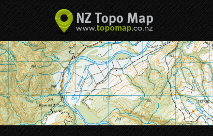
NZ Topo Map is an interactive topographic map of New Zealand using the official LINZ's 1:50,000 / Topo50 and 1:250,000 / Topo250 maps. Stewart Island, the Chatham Islands and other offshore islands are also covered.
An excellent research resource and a great reference for outdoors enthusiasts such as trampers, anglers, hunters, mountaineers, kayakers, etc.
Search and locate any landscape feature on the map: Towns, streams, caves, glaciers, forests, huts, mountains, and much much more!
Found what looking for and want to share it or bookmark it for later? Use the simple share functionality.
Want to print off a map to take it tramping with you? Use the advanced map printing functionality which results in high resolution map print-outs.
Need coordinates in NZTM or NZMG? Use the coordinate converter.
Got a Garmin GPS unit? Download Garmin Custom Maps to take map sheets offline and with you in to the bush.
User reviews
Safety
Risk impact
NZ Topo Map is relatively safe to use as it requires very minimum permissions.
Risk likelihood
NZ Topo Map has earned a fairly good reputation and likely can be trusted.
Screenshots


Promo images